Maps and Mapping of Norway, 1602-1855
Updates, by entry
[Most recent update: Aug. 1, 2015]
| 7 | Tore Gimse has informed me of what is possibly a proof state of the Waesbergen-Pitt map of Norway (fig. 7.0, p. 34). It lacks the printed sheet indicator ("XXV") in the upper left corner, but otherwise seems to be identical.
|
|
| 12 | This update clarifies some information about the privilege enjoyed by Johann Baptist Homann and the states of his maps. Tore Gimse originally raised some questions regarding my assertions. I thank him and Markus Heinz, a foremost Homann expert with whom I had subsequent correspondence, for leading me to the following corrections. Although I had correctly noted that Homann was granted a printing privilege posthumously in 1729, I did not know (and thus did not note) that the privilege was erased in 1750 or 1751 (from M. Heinz). As a consequence, a map without a privilege could have been printed pre-1729 or post-1750. For Homanns map of Norway, traces of the privilege may usually be discerned from copies printed after its erasure. The accompanying images illustrate the differences in the states. Fig. 12-1 shows a detail of the cartouche of state 1 of the map of Norway (as in fig. 12.0 on p. 78 of the book), and fig. 12-1a is a further detail. Note in particular the antennae of the shellfish under and at the end of Noribergæ.The cartouche of state 2 of the map is shown in fig. 12-2, (which is fig. 12.1 on page 79 of the book). As part of the introduction of the privilege, both antennae are now to the right of Noribergæ. Figs. 12-3 and 12-3a, after the removal of the privilege, are analogous to figs. 12-1 and 12-1a engraved prior to the privilege. The antennae have not been affected by the erasure. However, there are some small dots (perhaps most noticeable under the club) that are the vestiges of the peaks of some letters (e.g. the M) and of some dots over is. With respect to Homanns map of Fridrichshall (cf. fig. HOM 1 on p. 84), the first state without a privilege was issued c. 1720; the printing privilege defining state 2 was added around 1729. Then there would be a third state created by its removal in 1750. However, it would be difficult to determine this state because the erasure would not affect any other printed lines or letters. The situation is different for the map of southeast Norway (Aggerhusiensis). Figs. HOM 2-1, 2-2, and 2-3 show the cartouche for the first second and third states of the map. The privilege was added over the slight hill of hatching. When it was erased, the top of the hill was slightly flattened fig. HOM 2-3). Note that this is the state illustrated on p. 85 of the book, which is erroneously identified as state 1 (instead of state 3). Unfortunately, the information provided about the map of Bahus is also mistaken. Issued by Homanns son, this map had the privilege when first printed. Thus, in contrast to the Norway and regional maps discussed above, the presence of the privilege denotes the first state and its absence indicates the second state of the map (contrary to what is written in the book and incorrectly noted in the caption to fig. HOM 3 on p. 86). |
|
| 14 | This map, Regni Norvegiæ Nova et Accurata descriptio, was included in the Fall, 1716, issue of Relationis Historicæ Semestralis Autumnalis Continuatio. These booklets, published in conjunction with the spring and fall Frankfurt book fairs (Messen), are also referred to as the Messrelationen. Each issues roughly 100+ pages summarized the major historical, political, and military news since the prior fair; they are regarded as forerunners of modern day news magazines. The two lines at the bottom of the title page name the publisher in addition to the place and date: Franckfurt am Mäyn/|Bey den Engelhardischen Erben/und Joh. Balthasar Graupitzen/Not. Cæs. Publ. zu finden/1716. The first page of text contains a summary explanation of the volumes contents: Das ist:|Beschreibung der denckwürdigsten Geschichten/so von|jüngst = verwichener Franckfurter Oster biss an die|Herbst=Mess dieses lauffenden 1716. Jahrs sich hin und wie=|der in der Welt zugetragen. (This is: Description of the most memorable histories that occurred in the world during this current year 1716 from the recently elapsed Frankfurt Easter-fair to the autumn-fair.) Regni Norvegiæ Nova et Accurata descriptio is placed within the four-page section devoted to Sweden-Denmark-Holstein. The text covers the Norwegian Campaign of 1716, which was part of the Great Northern War, from around January to mid-July of that year. (The title page of the fall 1716 Relationis indicates that the issue covers the period before and between the Easter and autumn fairs. Though worded slightly differently from that translated above, the more accurate title page language reflects the delay in obtaining news and the time necessary to prepare the publication.) In the spring of 1716, Swedish troops under the command of King Karl (Charles) XII crossed into Norway and surprised the garrison at the Basmo Fortress with an unexpected night attack. (The fortress lies on an isolated mountain outcropping to the northeast of Fridrichshall. Karl XII was killed during the siege of Fridrichshall in 1718; see Entry 12, pp. 83-6 and fig. HOM 1.) According to the text, when Danish Brigadier Kruse got this news the following morning, he attacked the much larger Swedish forces. Although the attack threw the Swedes into initial confusion, a counterattack led by Karl XII himself captured Kruse, with heavy casualties on both sides. The text relates the following historical anecdote:
The vignette on the map is most likely intended to depictor at least to suggestthis harsh battle. The other major element of the map that differs from the Janssonius original, the addition of the numerous ships, probably alludes to a later phase of the Norwegian Campaign also reported in the text. In April, Danish Vice-Admiral Christian Carl Gabel set sail "with a favorable wind" to bring reinforcements. More importantly, in July, Peder Jansen Wessel (ennobled "Tordenskjold" by Frederick IV at the beginning of 1716) trapped and destroyed Karl XIIs supply fleet in the Dynekilen fjord north of Strömstad. - - - - - I appreciate the help of several people who assisted me on the journey of discovery to the elusive source of Regni Norvegiæ Nova et Accurata descriptio. Several years ago, Nils Germundson suggested that this map might come from an issue of the Messrelationen, but I was not able to confirm this. Recently, James Roy provided circumstantial evidence strongly corroborating this hypothesis, which persuaded me to renew my research in this direction. Bernhard Wirth of the Universitätsbibliothek Frankfurt am Main, whose help I gratefully acknowledge, has now verified this source. Mr. Wirth informed me (personal communication, November 19, 2010) that in the fall 1716 issue of Relationis Historicæ Semestralis, the eighth major section, titled "Von Schwedisch=Dänisch=und Hollsteinischen Geschichten," runs from the bottom of page 93 through page 97, with the map bound in between pages 96 and 97. In his opinion, there was usually just one plate added to issues in the 18th century, and that these were issued loose. The owner/purchaser could keep it separate, or bind or lay it in the volume. (I also wish to thank Dr. Wolfgang Cilleßen, Deputy Director of the Historisches Museum Frankfurt, for referring me to Mr. Wirth.) My thanks to Paul Garver for applying his remarkable translating skills to the relevant text and then providing historical background for the events described. |
|
| 15 | Before turning to the substantive comments that immediately follow, I apologize for failing to notice that the measurements of the map given in the summary cartobibliographic information heading the entry clearly do not correspond to its shape as shown in the illustration, fig. 15.0. The correct size of the map is 48.0 x 29.3 cm. - - - - -As a result of my further education through extensive correspondence with Roald Aanrud, which I gratefully acknowledge, I have learned that a number of statements in this entry require modification or correction. Since some of these changes pertain to Ove Andreas Wangensteen and Christian Jochum Pontoppidan, there are also corresponding revisions to entries 21 and 31/38 in this list of updates. Another source from which I have benefited is an article by Kristian Nissen, Bidrag til Norges Karthistorie, Norsk Geografisk Tidsskrift, v. IX, n. 5 (1943) (Bidrag). (A visual depiction of the relationships of the maps discussed following may be found here.) As noted in Entry 15, Melchior Ramus prepared a manuscript map of Norway for King Christian V. Although the original is lost, a few manuscript copies are extant. (Note 4 of the entry is relevant; unfortunately some of its details are incorrect, as discussed below.) Melchiors brother Jonas and Melchiors son Joachim Frederik (who became Jonass foster son) also prepared a map of Norway. Jonas and Joachim Frederik based their original map on sources different from those used by brother/father Melchior. The original Jonas/Joachim Frederik Ramus map is lost, though Delineatio Norwegiæ Novissima dated 1719 from Norriges Kongers Historie (entry 15) is a reduced size printed copy. The Gunnerus Library at the University of Trondheim possesses a full-size (140 x 79 cm) manuscript copy, Regni Norvegici delineatio novissima, signed by O.A. Wangensteen and dated January 1753. (In note 4 of Entry 15, this is mistakenly said to be a copy of the original Melchior Ramus map). Another manuscript map, designated NGO #78 in the archives of the Norwegian Mapping Authority (Statens kartverk), appears to be a copy of the 1753 Wangensteen map (or, less likely, both are direct copies of the Jonas/Joachim Frederik Ramus original). It is signed and dated in the title: Regni Norvegici Delineatio novissima finitimarumque Sveciæ Provinciarum Partes listens [...]S.O. de Falckenskiold Hafniæ 1757. Measuring 138 x 80 cm., it is essentially the same size as the Gunnerus/Wangensteen manuscript. Also virtually identical to that map is the Latin text running along the right hand side that gives a summary review of Norways history from Greek times and a brief account of Norways four bishoprics and their principal cities. (Seneca Otto von Falckenskiold, or Falkenskjold, 1738-1820, was born into a noble family and embarked on a promising military career. However, he became involved with Johann Friedrich Struensees period of de facto rule of Denmark.) The 1753 manuscript map by Wangensteen substantiates that Wangensteen knew the Jonas/Joachim Frederik Ramus map. However, Aanrud doubts that Wangensteen was familiar with copies of Melchiors map when he drew his map of Norway of 1761 (entry 21). Rather, Wangensteen based his work on military manuscript maps in the Danish archives, supplemented and corrected according to local military maps of parts of Norway. During the Seven Years War, 175863, Wangensteen was one of 15,000 Norwegian soldiers lying in readiness in Rendsburg along the Schleswig/Holstein border. As there was no war there, he had ample time for furthering his cartographic work. A manuscript map prepared by Wangensteen at that time shows the influence of the Jonas/Joachim Frederik Ramus depiction of the southern coast of Norway: Charta over Kongeriget Norge, aftegnet i Rendsborg, Aar 1759. af O.A. Wangensteén measures 66.5 x 47.7 cm and is in Frederik den Femtes Atlas at the Royal Library, Copenhagen (https://images.kb.dk/kortbog?b=41&s=41, accessed October 2012). With respect to the original Melchior Ramus map of Norway, Nissen in note 39 of his Bidrag refers to three manuscript copies. Two, both dated 1774, are in Danish archives and have attributions and specific references to Christian V in their titles: Norge copiered efter eet gammel Kort som under Christiani Qvinti Regjering er forfærdiget af Land Cadetterne Blücher, A. Arenfeldt, D. H. Kirchner, M. A. Sundt i Aaret 1774 (fig. 2 in Bidrag) and Kort over Norge, som er forfærdiget under Christiani Qvinti Regiering, og copiered af de Kongelige Land Cadetter i Aaret 1774 under Anviisning af deres Tegnemester C. Pontoppidan. These two show the straight, unrounded southwest coast of the country. The third manuscript copy of Melchiors map, Regni Norvegiæ Delineatio by Feuchter in the collection of the Norwegian Mapping Authority (NGO #6; correctly described in entry 15, note 4), shares the same coastal depiction. However, most importantly, there is no significant difference between Regni Norvegiæ Delineatio by Feuchter and Regni Norvegiæ Delineatio illustrated as figs. PON A/B in Entry 31/38 (pp. 126-7). Therefore, this latter manuscript is also a copy of Melchiors original map of Norway. (When Maps and Mapping of Norway was written and published, I had not seen the Feuchter map.) The minor differences between the two manuscripts are the larger area (by approximately two-thirds) of the Feuchter map and its simpler, unadorned cartouche. This update should be regarded as a work in progress, as I continue to research the incredible PON A/B map. |
|
| 21 | This entry correctly states that Ove Andreas Wangensteen had access to the original map Delineatio Norwegiæ by Jonas Ramus and Joachim Frederik Ramus and that the manuscript signed A. O. Wangensteen in the Gunnerus Library is a copy of that original. (Note 4 in entry 15 mistakenly says it is a copy of the original Melchior Ramus map.) See also the update for entry 15 above for information about another manuscript map by Wangensteen that shows the influence of Jonas and Joachim Frederik Ramus. |
|
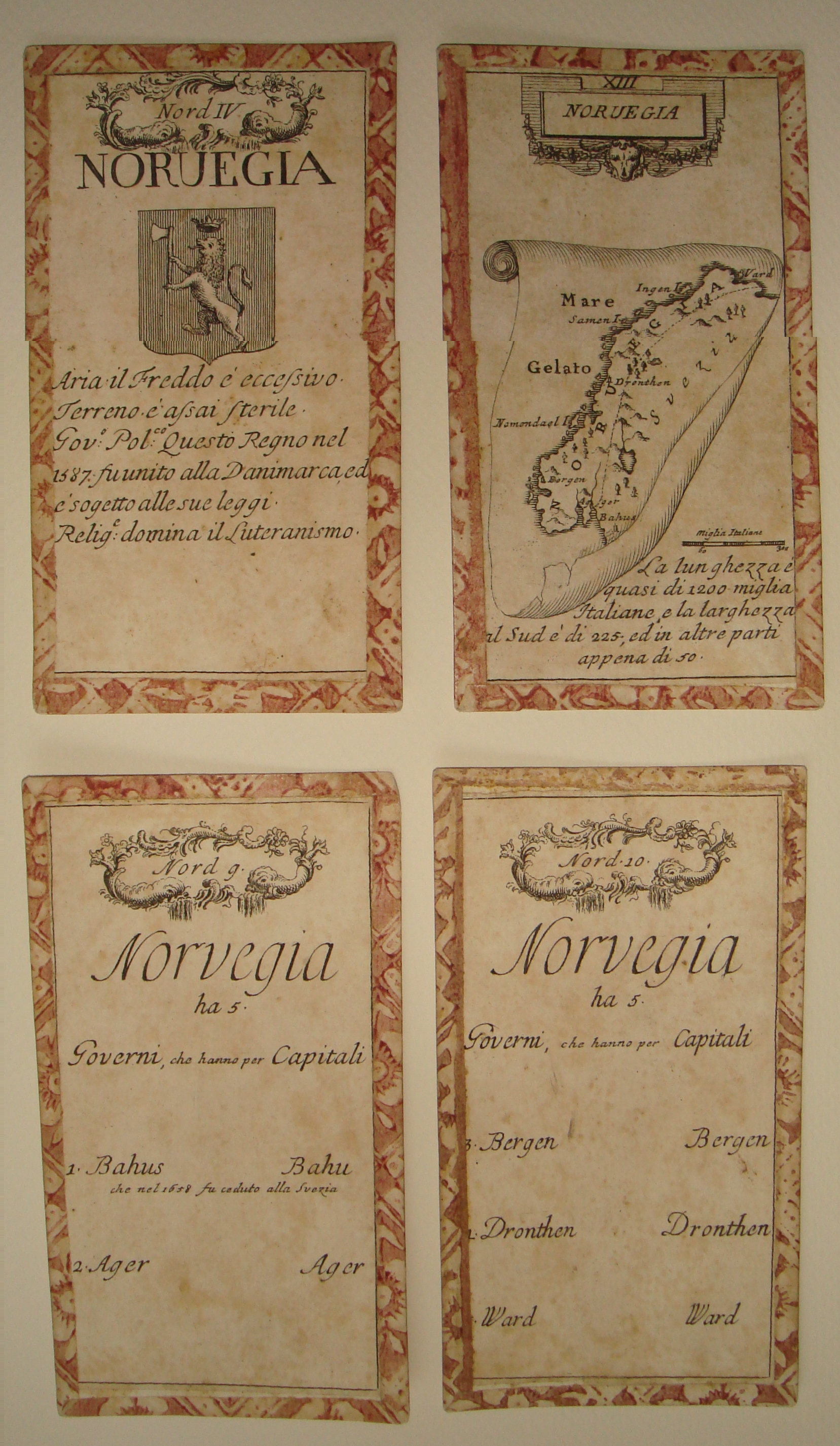
| 25+ | New Entry Fig. 25+.0.
NORUEGIA Naples, c. 1770 11.4 x 5.8 cm. From Gioco Geografico dell'Europa, a pack of Tarot cards As discussed in Entry 5/30, playing cards with maps are rare, with most of those that are known picturing county maps of England and Wales, which conveniently number 52. Because playing card maps of other parts of the world are so uncommon, this update presents related images in addition to that of the new entry. Gioco Geografico dell'Europa consists of 78 cards, with the 20 atouts (numbered "II" through "XXI") showing maps on scrolls. Two cards have the principal rivers of Europe, one for those flowing into the Mediterranean and the other with the ones emptying into the ocean. The remaining 56 are divided into 4 groups: south, central, north, and islands. The 14 cards in each group have coats of arms on cards I-IV and associated text on cards 1-10. Figure 25+.0 illustrates the three categories: the Norway map on atout "XIII," the Norwegian coat of arms on the "Nord IV" card, and corresponding text on "Nord 9" and "Nord 10." The words on Noruegia read "La lunghezza è quasi di 1200 miglia Italiane, e la larghezza al Sud è di 225; ed in altre parti appena di 50 (the length is almost 1200 Italian miles, and the width in the South is 225; and in other parts just 50). Only a handful of place names are denoted. According to the lines below the coat of arms, the air is excessively cold and the land is very sterile; regarding the political government, the kingdom was united in 1387 by Denmark and is subject to its laws [note: this is most probably a mis-dated reference to the Kalmar Union, which was established in 1397]; Lutheranism is the dominant religion. I was aware of at least one card from this set–figure 30.4 (page 63) illustrated the map of Denmark–but I did not know that the pack also included a separate map of Norway. Figure 25+.1 includes the coat-of-arms and text cards for Denmark ("Nord III" and "Nord 8") and repeats the map atout ("XIIII"). Figure 25+.2 displays the analogous cards for Sweden (atout "XV,", "Nord II," "Nord 6," and "Nord 7"). The information on the Denmark and Sweden map and coats of arms cards are analogous to those for Norway described above. Other map cards in the set are those of Europe (fig. 25+.3) and of the other four continents (fig. 25+.4) A further two images augment the original Entry 5/30. There, figures 5.4 and 5.5 illustrated the Norway/Sweden and Denmark cards from a deck by Johann Hoffman dating to 1678. Here, figure 25+.5 supplements the Scandinavia maps with the world (ace of spades) and Europe (ace of hearts) cards from the Hoffman set. The second of the two, figure 25+.6, depicts a map of LA SVEZIA (Sweden) on a card, albeit not a playing card. Published by P. Zaricen in 1794 in Venice and measuring approximately 6.0 x 8.8 cm, it was produced as part of a set of visiting cards. The caller could insert his signature in the blank panel above the title. The publisher's imprint, which occupied two lines below the title, was deleted in a second issue of 1799; one can detect faint signs of erasure on La Svezia (fig. 25+.6). |
|
| 31/38 | With respect to C. J. Pontoppidans map of southern Norway (entry 31), Myles Baynton-Williams of the Altea Gallery has informed me of a state of the map with the following printed at the lower right below the map border: Findes til kiöbs hos Ioh: G: Blanckensteiner i Kiöbenhavn paa Östergaden No 36. (See fig. 31.0a.) The series of addresses of Pontoppidan's shops (see n. 4, p. 127) indicates that this version is state 2 of the map, and the ones previously denoted states 2 and 3 actually represent a third and fourth state, respectively. Note that the Östergaden 36 address is that found on the first state of Pontoppidan's map of northern Norway (entry 38). As discussed above in the update for entry 15, the map illustrated as figs. PON A and PON B on pp. 126-7 in the book is actually a copy of the original, and now lost, map of Norway by Melchior Ramus. (Pontoppidan was involved in the supervision and drawing of one of the manuscript copies of the original Melchior Ramus map that is now held in the Danish archives. For a visual depiction of the relationship between the various maps discussed, click here.) |
|
| 33 | Dr. Markus Heinz (see updates to entry 12 above) has informed me that Franz Ludwig Güssefelds Charte vom Koenigreich Norwegen exists in a second state, issued between 1791 and 1800, in which two place names were added: Christianstein just below Drontheim and Christiansholm just above Bergen. As a consequence, the map illustrated as fig. 33.0 on p. 130 is really state 2, and the 1805 improved version (of which the cartouche is shown in fig. 33.2 on p. 132) represents state 3 of the map. |
|
| 42+ | New Entry Fig. 42+.
Thomas Dix London, 1809 Norway. Above map at upper right: 16 Below bottom map border: Drawn by Tho.s Dix, for the Use of Schools. At bottom center of sheet: London, Published as the Act directs by W. & T. Darton, Dec.r 10th.1809. This small unadorned map of Norway comes from an English school atlas whose title page reads: DIX's|Juvenile Atlas,|CONTAINING|Forty Four|Maps|with plain directions for copying them,|DESIGNED FOR|Junior Classes.|LONDON|Published Jan,y 1st, 1811, by William Darton Jun.r 58 Holborn Hill. It is a reminder that there are likely to be analogous maps of Norway in at least some of the school atlases that proliferated in Europe and America during the 19th century. Norway is another example of a map present in this cartobibliography primarily due to its title (see especially Entries 8/9 and 10). The sheet includes Sweden and most of Finland, with virtually no geographical information about them. Not much more is shown in Norway, with only Christiania and the Lofoden (sic) Isles indicated. |
|
| 46+ | New Entry Fig. 46+.
Vargas Bedemar Frankfurt am Main, 1819 untitled geological map of Norway Below map at lower left: Vargas Bedemar 2te Theil. Below map at lower right: Steindruck von Joh: S[usenbeth] 36.2 x 29.0 From Reise nach dem hohen Norden durch Schweden, Norwegen und Lappland in den Jahren 1810, 1811, und 1814, vol. 2. Balthazar Mathias Keilhau is credited with creating the first complete geological map of Norway; although he may have been contemplating this as early as 1822, fulfillment came only with maps dated 1844 and 1849 that appeared in Gaea Norvegica (entry 69/77). Although hardly a precursor, in 1838, Francesco Constantino Marmocchi had delineated the two major geological divisions of the country on his reworking of Bartolomeo Borghis map of Norway (entry 46, fig. 46.1, p. 159). This small unadorned, untitled map by Vargas Bedemar predates those of B. M. Keilhau by a quarter of a century, and it is almost 20 years older than that of Marmocchi. In the book indicated above, it is an attachment to the 55th chapter (pp. 302372): Geognostischer Umriss von Norwegen (Geognostic outline of Norway). The color code defines five different geological categories that appear approximately 100 times on the map, predominately in the south (fig. 46+). Vargas Bedemar, who titled himself Edouard Romeo count Vargas-Bedemar, was the pseudonym of Carl Friedrich August Grosse (born 1768 in Magdeburg; died 1847 in Copenhagen). An adventurer, soldier of fortune, and charismatic confidence man, Bedemar spent several years in southern Europe before arriving in Copenhagen in 1809, where he had already been elected (in 1806) to the Danish Academy of Sciences. He leveraged his friendship with members of the royal family to obtain sponsorship for travels, including that denoted in the title of the book above, to collect geologic and mineral specimens. In 1842, he was appointed head of the Natural History Museum in Copenhagen. See also New Entry 87 below for another geological map of Norway. |
|
| 77 | The first name of the cartographer is misspelled. It should read Balthazar, as in the heading for Entry 69 printed above it. |
|
| 78+ | New entry Fig. 78+.
G. C. C. W. Prahl Bergen, c. 1850 Det sydlige|Norge.|Forlag og Lith: ved Prahl i Bergen Lithograph, 24.7 x 18.6 cm From Prahl's Nyeste Norske Skole Atlas |
|
| 78++ | New Entry Fig. 78++.
G. C. C. W. Prahl Bergen, c. 1850 Det nordlige|Norge.|Forlag og Lith: ved Prahl i Bergen Inset map at lower right: Christiania=Fjord med Omgivelser. (19.3 x 11.5) Lithograph, 18.4 x 24.6 cm From Prahl's Nyeste Norske Skole Atlas At the top of page 199, I wrote that I had seen title references to at least three Prahl atlases that I had not been able to locate. In April 2010, I obtained a copy of the second edition of Prahl's Nyeste Norske Skole Atlas. The continuation of the title refers explicitly to the Geographies of Geelmuyden, Platou, Daa, and Knutzen. There is no date on the volume or printed on any of the maps. The words "Andet Oplag" (second edition) are printed on the title page and on most of the maps, and Prahls Mindre Skole-Atlas is printed above the border on almost half of the maps. In this work, there are maps of southern and northern Norway (Fig. 78+/78++) that are analogous to Entries 61 and 63, but only approximately one-quarter the size; namely, 24.7 x 18.6 cm. (vs. 50.0 x 34.0) and 18.4 x 24.6 cm. (vs. 34.0 x 50.0), respectively. Det sydlige Norge, the map of southern Norway, has "Andet Oplag" printed within the map border at the upper center, but these words do not appear on the map of northern Norway, Det nordlige Norge. (My hypothesis is that the pair was regarded as a single entity-in fact, they are noted as "5 og 6. Norge" in the contents printed on the title page-so that "Andet Oplag" effectively applied to the map of Norway that happened to have been printed in two parts on facing pages.) Neither map carries any reference to Prahl's Mindre Skole-Atlas. Although I have dated both maps c. 1850, this is an estimate based on the following considerations. To begin, the reference on the atlas title page to the Geographies of Geelmuyden, Platou, Daa, and Knutzen is, unfortunately, not determinative because various books by these authors with geography in the title were issued from 1840 into the 1900s. For example, Platou's Lærebog i Geographien came out in 1840, though it had been published as a set of pamphlets already in 1835; first editions of Geelmuyden's Geografi for Begyndere and Lærebog i Geografien til Skolebrug are both dated 1851 (with the tenth edition of the latter appearing in 1900); and although Daa's Lærebog i Geografien is dated 1859, his Udtog af Geografien was published in 1841. My choice of date rests primarily on the presumed chronological ordering of Prahl's publications in J. B. Halvorsen and Halvdan Koht, Norsk forfatter-lexikon, 1814-1880; Paa grundlag af J.E. Krafts og Chr. Langes "Norsk forfatter-lexikon 1814-1856," Kristiania: Den Norske forlagsforening, 1885 (page 481), in which the Mindre Skoleatlas is ascribed a date of "184*", followed by Prahls nyeste norske Skole-Atlas, then Kart over den sydlige Deel af Kongeriget Norge, udarbeidet til Brug for Skoler og privat Undervisning (Entry 86, which I assigned a date of c. 1855 while noting that it "could be off by ten or more years"), after which comes Prahls Godtkjøbs-Atlas with a date of [1858]. Secondarily, from the absence of a reference to the Mindre Skoleatlas on the two sheets of the Norway map, I infer that they were not included in that book but were introduced later in Prahls nyeste norske Skole-Atlas. |
|
| 85 | There is a 6th edition dated 1873 ("6de Oplag 1873" in the title) of P. A. Munch's Kart over Kongeriget Norge. |
|
| 87 | New entry Fig. 87a,b.
J. Durocher Paris, 1855 southern sheet (fig. 87a) CARTE|GÉOLOGIQUE et MÉTALLURGIQUE|de la|SCANDINAVIE|dressée par J. DUROCHER|d'apres les indications fournies par les Cartes|de|MM. HISINGER et KEILHAU|Conjointement|avec les observations de l'Auteur|1855. Below map at lower left: Gravé chez Erhard-Schieble, R. Bonaparte, 42. Below map at lower right: Imprimé chez Kaeppelin, Q. Voltaire, 17, Paris. Title of table at lower right of sheet: Explications des Signes conventionnels et des Couleurs. 53.4 x 70.7 untitled northern sheet (fig. 87b) Heading of drawings along left half of sheet: COUPES ET VUES GÉOLOGIQUES RELATIVES A LA NORWÈGE, LA SUÈDE, ET LA FINLANDE 53.5 x 70.8 From Atlas Géologique This pair of maps appears in the volume Atlas Géologique, Gravé d'après les dessins de M. Durocher that comprises a part of the 23-volume Voyages de la Commission scientifique du Nord, en Scandinavie, en Laponie, au Spitzberg et aux Feröe, pendant les années 1838, 1839 et 1840 of Paul Gaimard. The table listing the maps and plates notes that the scale is 1/1830000 or 1 mm per 1830 meters. Although the title refers to Scandinavia, its focus on Norway warrants inclusion in the cartobibliography. (This situation is the reverse of a few other entries in Maps and Mapping of Norway in which the titles refer to Norway though the maps themselves portray almost as much informationalbeit meagerof Sweden. See, especially, entry 10; also entries 8 and 9.) Joseph Marie Élisabeth Durocher (1817, Rennes1858, Rennes) was a French geologist who accompanied one of the expeditions of Paul Gaimard aboard La Recherche and authored Géologie, Minéralogie, Métallurgie et Chimie, one of the volumes of Voyages en Scandinavie, en Laponie, au Spitzberg et aux Feröe. From 1844, he was professor of geology and mineralogy at Rennes. The title on the southern sheet refers to information provided by the maps of Hisinger and Keilhau as well as observations of the author. Wilhelm Hisinger (17661852), a Swedish chemist and physicist best remembered for his work with Jöns Jacob Berzelius (e.g. the discovery of cerium and the study of electric currents in salt solutions), traveled extensively in Scandinavia studying Swedish and Norwegian geology and paleontology. He published Antechningar i physik och geognosie under resor i Sverige och Norge, 181939 (Notes in physics and geology while traveling in Sweden and Norway, 181939). |
|
| PRA 1 | In this essay, which is part of the entry of maps by Georg Carl Christian Wedel Prahl beginning on page 195, it is mistakenly stated (pp. 199, 203), that the map is associated with the major Norwegian artist Anders Monsen Askevold (1834-1900). Instead, the reference should be to the lithographer Anders Madsen Askevold (born Askvoll, in 1842; date of death unknown). I thank Pål Sagen for pointing out this correction made by Anders Kvernberg and Bededicte G. Briså.
|
|
| Essay | Route Maps
In Table 1 on page 247, there should be an additional line for the year "1898" with the number "4" in the last column indicating the fourth edition of Cammermeyers Reisekart over northern Norway. The following text should be added to the end of the first column on page 256: 4TH EDITION, KRISTIANIA 1898 Cammermeyers Reisekart|over|Det nordlige Norge.|I 4 Blade.|Udarbeidet af Per Nissen.|4de rettede Oplag.|Kristiania 1898.|Alb. Cammermeyers Forlag. In both this and the prior third edition, the date is given under the title, which is printed on the northwest (upper left) sheet. In the southwest sheet, there are features shown in Sweden, to the east of the Norwegian border; and the first column of the list in Table B at the lower right ends with "Grøto" (the last word in the 1893 edition is "Tranø"). The northeast sheet has an area labeled "FINLAND RUSLAND" with corresponding features and details. The data in the tables comprising the southeast sheet refer to different years: e.g., third table along left hand side, 1896 (1891 in 3rd edition); fourth table, 1891-1895 (1886-1890 in 3rd edition); under the center table at the bottom, 1891-1895 (1881-1890 in 3rd edition). |
