Sea Charts of Norway, 1585-1812
Updates, by chapter
[Most recent update: Aug. 2, 2015]
4 |
The image in fig. 4A.7b on page 86 should be rotated 180°. In the accompanying caption, the word “clockwise” should be replaced with “counter-clockwise”. |
12 |
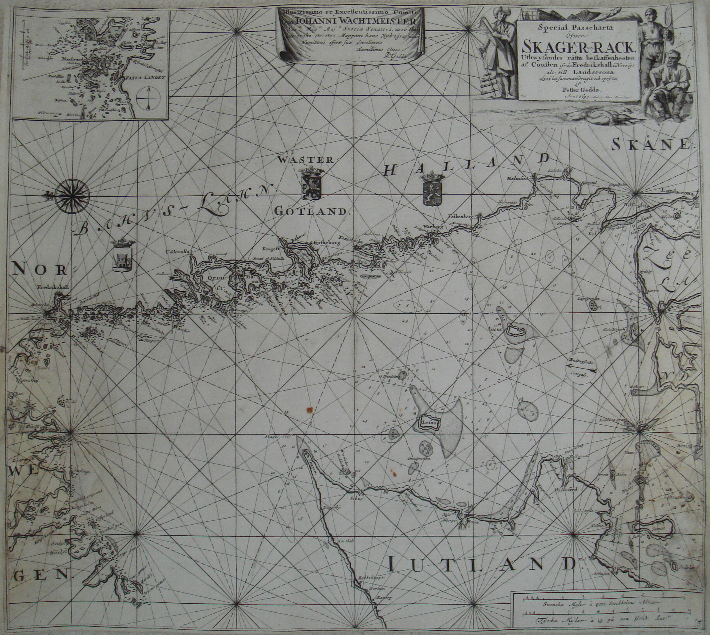
On page 253, Anders Höeg is referred to as Danish. He was Norwegian. - - - - Peter Gedda (1661-1697) and Nils Strömcrona (1664-1740), Gedda's successor as Captain of Sailing Masters and Director of Pilots, are mentioned on page 257 at the beginning of the "Swedish Marine Cartography" section, though none of their work is illustrated. We now remedy that omission with a chart from each covering the Skaggerak and surrounding area: Petter Gedda (fig. 12PG.1) Special Passecharta|Öfwer|SKAGER-RACK,|…|af|Petter Gedda.|Anno 1695.|Med 10 Åhrs Privilegio. 52.8 x 58.8 cm Inset map of entrance to Marstrand at upper left Dedication in top center cartouche to Hans Wachtmeister (1642-1714, admiral general of the Swedish navy and governor of Kalmar-Blekinge county when the naval base in Karlskrona was set up) Nils Strömcrona (fig. 12NS.1a, fig. 12NS.1b) General Hydrographisk Charta|öfwer|STORA och LILLA BELT|med CATTIGAT|…|af|Nils Strömcrona. c. 1737 52.5 x 104 cm 5 inset maps: Inloppen till Giötheborg; MARSTRANDS|Hamn; Inloppen till och ifrån Kongshamn; Inloppen till Mahlöö-|Sunds Hamn; WISMAR STADS|Redd och Inlopp. Gedda's chart appeared in 1695 in General-Hydrographisk Chart-Book öfwer Östersiön, och Katte-Gatt in which it was the third of ten maps (increased to 12 in a second edition of 1699). Dutch (Generale en verscheyde Speciale Pas-Kaerten Over De geheele Oost-Zee, Ende het Schager-Rack) and English (A general, and different special Sea-Charts of the whole East-Sea and the Schager Rack) editions were also published that year with the same charts retitled in their respective languages. Stylistically, the map is most similar to a large chart by Johannes II van Keulen made around 1750 (figs. 8B.12a, 8B.12a1, and 8B.12a2 on p. 155). Although recognizing the weaknesses of Gedda's atlas, Strömcrona made relatively few improvements in his own General och Åtskillige Speciale Pass-chartor Öfver Hela Öster-siön (General and Various Special Compass Charts of the Whole Baltic Sea) published in 1739. His version of Gedda's map extends slightly further to the south and has five harbor inset maps. For more information, see Ulla Ehrensvärd's masterful The History of the Nordic Map, Helsinki: John Nurminen Foundation, 2006, "Chapter X. Sailing Masters, Pilots and Improvements to Sea-Charts," especially from p. 272. |